Overview
![]() Area: Dhauladhar, Himachal Pradesh
Area: Dhauladhar, Himachal Pradesh
![]() Duration: 09 Days
Duration: 09 Days
![]() Best Season: May to October
Best Season: May to October
![]() Grade :Moderate
Grade :Moderate
![]() Altitude: 4375mts/14245 ft
Altitude: 4375mts/14245 ft
![]() Total Trekking: 35 K.M
Total Trekking: 35 K.M
About Indrahar Pass Trek
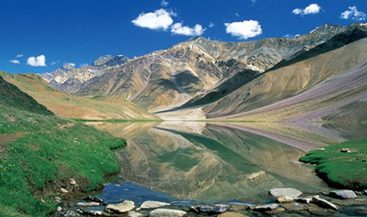
With beautiful landscapes, sparkling streams, deep gorges, tranquil lakes and deodar forest all throughout the journey, the Indrahar Pass Trek in Himachal Pradesh is one of the most awe – inspiring treks in the Indian Himalayan region that bursts the mind of several travelers from all age group. The journey is a perfect combination of diverse nature and traditional colors of Himachal, and it stretches from an elevation of 2,875 meters to 4,425 meters. The Indrahar Pass forms the border between Kangra and Chamba districts and lay bare the stretch of Dhauladhar range with the fascinating glimpse of hamlets below. It also uncovers the tranquil waters of Lake Mankiani and Kareri. Nonetheless, the dark boulder road tracks of the Dhauladhar and rhododendrons and a wide range of avifauna at different altitude simply enriches the journey and wins the heart of travelers.
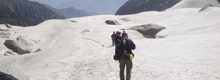
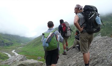
The Indrahar Pass trek, which is one of the easy to moderate treks in Himachal Pradesh, takes off from McLeodganj, which is the seat of Dalai Lama, to Triund at 2,875 meters. The trek to Triund via Dhramkot village and Galu Devi reveals a magnificent view of the Kangra Valley and Dharamshala town below. From Triund, the trail leads off to Lahesh Cave via Laka passing through a meadow scattered with boulders. From Lahesh Cave the journey for the day commences for Indrahar Pass walking over the rocks straight on the North East face of the ridge, keeping the steep wall of Mon to its right. The trail continues over the crest and comes across several ascents. The view from the pass is just mind blowing. To the south lie the Kangra valley and the distant plains of Punjab in a blue haze, while up north rises wave upon waves of ranges like the Pir Panjal to the north, Kishtwar to the west, Bara Bangahal to east and Manimahesh to the northeast. The trail further continues down to Chhata passing through an untamed stream over the dark boulder and expunges into a beautiful valley dotted with several species of wildflowers. From Chhata, the route snakes to Kuarsi via Kuarsi Nala and leads off at Brehi en route to Lamu followed by Donali. Brehi is the gateway to Minikiani Lake, and the track passes through a dense forest via Drakund. After crossing the Minikiani Lake, the route leads to Kareri Lake and then to the camp at Kareri followed by the downhill trek to McLeodganj.
Indrahar Pass Trekking Tour Highlights
- Clear views of the Dhauladhar and Pir Panjal range of mountains
- Catch glimpses of famous peaks like Moon (4666 m), Arthur’s Seat (4525 m), etc.
- Camping in Lahesh Cave, a natural rock shelter
- Night stay in hotel/Guest House/Camp
- Visit beautiful Chamba Valley
Best Time to Visit Indrahar Pass Trek
May to Mid-October
During the early months of the year, there are chances of snow on high passes, which considerably melts by August. During the monsoon season, Kangra and Dhauladhar range remains affected due to rain, but when we talk about the high places, the weather is warm and sunny (12-20 °C) during the day, while the night temperature could be in minus (-2 to 6 °C). During the September and October, trekkers can experience a good weather, with little snowfall. With the onset of October, the day temperature is hovering around 12-18 °C but the evening starts getting comparatively colder with (- 6) to 4 °C.
Where is the Indrahar Pass Trek ?
Indrahar is a mountain pass in Dhauladhar range of Himalaya, at an altitude of 4342 meters (14245 ft) above the sea level. Famous for its trekking trails, the pass is mainly a frontier which divides the famous districts of Himachal Pradesh- Kangra and Chamba. Best time to go for trekking to Indrahar Pass is between May and October.
How to Reach Indrahar Pass Trek ?
By Road:Dharamshala is well-connected with all the major cities of North India, including Delhi, Chandigarh, Manali, Srinagar, and Dehradun, via state-owned buses and private taxis.
By Railways:Pathankot Railway Station is the nearest railway station, which is 84.5 km from Dharamshala.
By Air:Gaggal Airport, commonly known as Kangra Airport, is the closest runway to Dharamshala. From the airport, cabs and buses are easily available.
Indrahar Pass Trek (Detailed Itinerary)
Day 01: Delhi – McLeodganj (2196 mts/7,200 ft)
In the evening, you will board AC Volvo Coach to McLeodganj from one of the meeting points in New Delhi. Overnight Journey.
Day 02: Arrive McLeodganj
At 03:30 AM, trekkers will arrive at Chakki Bank and then they will be transferred to another vehicle, which will drop them at McLeodganj hotel. On this day, you can either choose to relax in the hotel or can explore McLeodganj. In the evening, guide of the trek will hold a training session to instruct and distribute the instruments for trekking. Dinner and overnight stay in a hotel.
Day 03: McLeodganj – Triund (2994 mts/9818 ft.) 10 kms/3-4 hrs
Rise and shine, kick start your first day of trekking with a 10 km trek to Triund via Dhramkot. Dinner and Overnight stay in Triund camp.
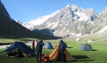
Day 04: Triund – Lahesh Cave (3598 mts/11800 ft) 9 kms/ 3-4 hrs
Post breakfast; get set ready to reach the destination of today, Lahesh Cave. To approach the cave, you will have to cross the bridges and walk on the flowering ground, under Oak and Conifer trees silhouettes. Overnight stay in Lahesh Cave campsite.
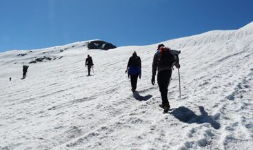
Day 05: Lahesh Cave – Indrahar Pass (4375 mts/14,350 ft) – Chatru Parao (12 kms/6 -7 hrs)
Finally, the day has come, when you will be trekking on the snowfield of the Indrahar Pass. Post breakfast; start trekking uphill towards Indrahar Pass, which is going to be a little harsh as there will be 300 – 400 m steep climbing. It will be challenging, but when you reach the pass, rewarding view of Pir Panjal Range (4,100 m) in the north and Mani Mahesh Kailash (5656 M) peak in the east will compensate all the effort. After spending some time at the pass, trek back to Chatru Parao. Overnight stay and dinner in the Chatru Parao tent.
Day 06: Chatru Parao – Kuarsi (2747 mts/9010 ft) 15 kms/ 6 – 7 hrs
For the first few kilometers, trek to the left side of the valley, after few kilometers there will be a bridge, cross it and follow the series of meadows till Kuarsi, which will take you to the right side of the valley. Dinner and overnight stay in Kuarsi camp.
Day 07: Kuarsi – Machetar (5886 ft) – Chamba (16 kms/5 – 6 hrs) Traveling 80 kms/3 – 4 hrs
Following today’s breakfast, get set ready for a downhill trek till Machetar. At Machetar, our drivers will be waiting to drop off at Chamba hotel. Dinner and overnight stay in Chamba FRH/hotel.
Day 08: Chamba – Pathankot – Delhi
Post breakfast, we will drive to Pathankot. From Pathankot, we will board a train to Delhi at 23:55 hrs. Overnight journey.
Day 09: Delhi
Arrival in Delhi marks the end of Indrahar Pass Trek.
Tour & Services End.
Things to Carry for Friendship Peak Trek
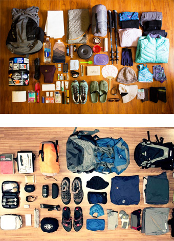
- Duffel bag Down/synthetic camp booties
- Sunglasses, Light gloves
- Sleeping bag
- Flashlight/Headlamp with extra batteries
- Daypack
- One liter water bottles wide mouthed
- Trekking Boots
- Water purification/filter
- Camp shoes/sneakers
- Walking stick/Trekking pole
- Cotton socks
- Note book with pens and pencils
- Gore-Tex jacket
- Lip balm
- Light wind jacket Sunscreen / Moisturiser
- Down jacket/vest
- Camp towel/towel/sarong
- Fleece jacket/vest
- Personal toiletries
- T-shirts
- Personal medicines
- Underwear
- Money pouch/belt
- Trekking pants
- Energy bars
- Thermal tops
- Vitamin tablets
- Thermal bottom
- Extra passport photos
- Warm hat and Bandana/scarf
- Sun hat/baseball cap
- Wind- and rain-gear with hood
- Swiss Army Knives (Classic pocket tool)
- One pair cotton trousers or shorts
- Two cotton shirts/T-Shirts One warmer (jacket with hood)